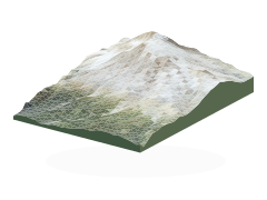
The mountain,
as it really rises.
Explore Mount Rainier’s ridges, glaciers and park-wide trails in a geographic landscape built from measured elevation and aerial photography.
Terrain: USGS 3DEP, with true vertical scale. The desktop grid is 4.47 m around Paradise, 13.4 m across the central massif, and 27–54 m across the wider park. Smaller screens use 13.4 m in Paradise and 54–107 m for the outer landscape. The detailed Paradise relief comes from 2008–2009 surveys.
Photography: USDA NAIP, July–August 2023. Close-view imagery reaches about 0.6 m per pixel within roughly 1.2 km of all eight visitor-area centres, including on smaller screens. Outside these close-ups, imagery ranges from 0.76 m around Paradise to 5.2 m across the wider park. Distant views load lighter imagery.
Places, roads and recorded building footprints come from the National Park Service; trails come from OpenStreetMap and NPS. The complete queried network includes connecting paths, informal and alpine routes. NPS alignment variants are searchable and appear when selected. Individual rocks, trees and buildings appear in the photography, but are not separate 3D objects. “View toward the summit” places the camera 8 m above the elevation surface.
Place close-ups: all visitor areas and mapped places have native 0.6 m aerial coverage nearby, loaded as you zoom in on desktop or mobile. Very close zooms still reveal the photograph’s resolution limit. This sharpens the photography without adding building, tree or rock geometry.
These are historical images, not live conditions. Snow cover, access and routes can change. Use official destination maps and current access information when planning your visit.
USGS 3DEP · USDA NAIP imagery · © OpenStreetMap contributors
Visit the official destination guide